- 196
- 217shares

South Yuba River State Park is a beloved destination nestled along the Yuba River in California’s Sierra Nevada foothills. Spanning nearly 20 miles of historic Gold Country—from Malakoff Diggins State Historic Park to the river’s scenic banks—the park delivers stunning vistas and endless outdoor pursuits for nature lovers, history enthusiasts, and adventure seekers alike.
Why Visit South Yuba River State Park?
This hidden gem in the Gold Country offers a perfect escape from urban life, blending rugged natural beauty with rich California history. In spring, witness roaring snowmelt cascading over granite boulders, fueling vibrant wildflower blooms and crystal-clear swimming holes. Summer brings ideal conditions for hiking, gold panning, and fishing in calmer waters. Fall paints the canyons in golden hues, while winter offers serene, uncrowded trails. With over a dozen trails, historic sites, and wildlife-viewing opportunities, it’s an affordable, family-friendly day-trip destination.

Hiking Trails: Independence Trail, a 2-mile accessible route
Explore more than a dozen trails, from gentle strolls to challenging treks through deep canyons lined with black oaks, gray pines, and Douglas fir. Highlights include the nation’s first wheelchair-accessible wilderness trail, ensuring inclusivity for all visitors. Co-managed by California State Parks and the non-profit Sequoya Challenge, this innovative path transforms a historic aqueduct into a 2-mile accessible route. Wheelchair users and hikers alike can navigate forests, rocky outcrops, waterfalls, and mountain streams that cascade into emerald swimming holes—perfect for summer dips.

Secret Swimming Holes & River Playgrounds
While the Yuba’s main channel surges with cold, swift currents unsuitable for casual swims, hidden pockets of calm create idyllic family havens. The star attraction is the gentle beach near Bridgeport, accessed via Pleasant Valley Road off Highway 20 (east of Marysville). Here, shallow gravel bars and slow eddies invite kids to splash, build cairns, or skip stones under shady oaks.
Upstream gems like the pools below Independence Trail’s flumes offer deeper, turquoise basins ringed by sun-warmed boulders—ideal for a refreshing plunge after a hike. Pack water shoes to navigate slippery rocks, and always scout depths; flash floods can reshape holes overnight. Lifeguards are absent, so adult supervision is essential.

Bridgeport Covered Bridge: A Timber Titan Over Time
Step inside the longest single-span covered bridge in the U.S. (built 1862) and feel the river’s thunder vibrate through 150-year-old Howe trusses. Spanning 251 feet, this National Register landmark once carried stagecoaches, miners, and gold-laden wagons. Peer through side windows to watch kayakers shoot the chute below or spot trout darting in sun-dappled currents. Interpretive panels reveal engineering marvels—like iron tension rods that prevented collapse during 1960s floods—and ghost stories of lantern-lit crossings. Picnic tables flank the north end; arrive early on weekends to claim a spot for bridge-side lunches with a whitewater soundtrack.

Spring’s Wildflower Symphony & Avian Chorus
From March’s first lupine bursts to May’s farewell poppies, the park erupts in a 20-mile floral corridor. Look for shooting stars, brodiaea, and rare phantom orchids along the Point Defiance Loop Trail. Free docent-led wildflower walks (Saturdays/Sundays, 10 a.m.) include macro lenses for close-ups and tales of Gold Rush botanists. Birders, meanwhile, tally 100+ species: canyon wrens trill from cliff faces, dippers bob on midstream rocks hunting caddisflies, and acorn woodpeckers hammer “granaries” into snags.
Fall migration adds warblers; download the park’s eBird checklist or join guided walks to spot elusive golden-crowned sparrows in manzanita thickets. Pro tip: dawn at Jones Bar rewards with owl calls and mist-shrouded river views.

Wild Residents: From Bears to River Otters
Black bears descend from high ridges in late summer, raiding manzanita berries—store food in bear boxes at trailheads. Mountain lions patrol remote canyons (sightings are rare, but tracks are common near Purdon Crossing); hike in groups and keep dogs leashed. Coyotes yip at dusk, while bobcats stalk quail in chaparral. River otters, reintroduced in the 1980s, now frolic below Edwards Crossing, spiraling after salmon smolts. Mule deer browse meadows at sunrise; rattlesnakes sun on south-facing slopes (watch children near rock piles).
The park’s “Leave No Trace” ethos ensures these creatures thrive—pack out all trash to avoid habituating wildlife.

Cast & Reel: Prime Fishing on the Yuba
Post-runoff (typically mid-June), the river drops to wadeable levels, revealing riffles packed with wild rainbow trout (10–16 inches common). Fly anglers favor Rush Creek’s pocket water with caddis imitations; spin-casters toss Panther Martins near Bridgeport. Smallmouth bass lurk in deeper holes below Purdon; try crayfish patterns at dusk. A California fishing license (age 16+) is mandatory—buy online or at Grass Valley sporting goods stores. Barbless hooks and catch-and-release are encouraged in the park’s wild trout section.
Bonus: October brings spawning browns from Englebright Reservoir; sight-fish them in crystal shallows with patience and polarized glasses.

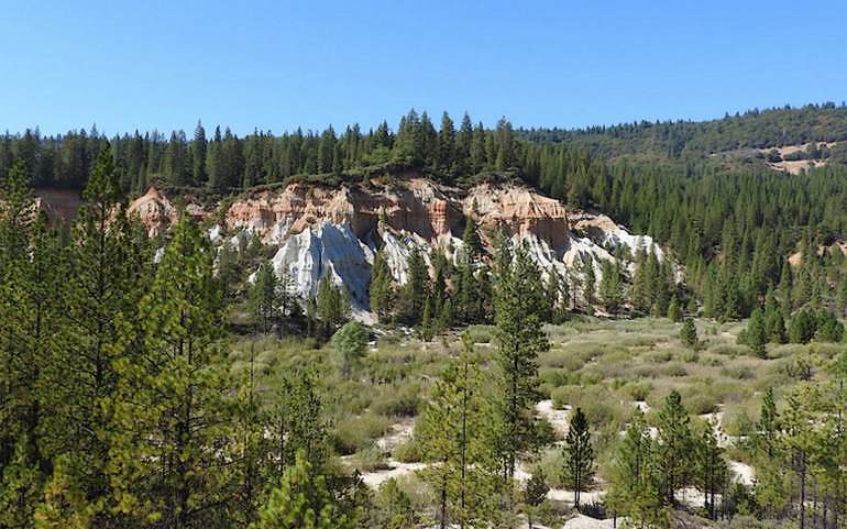
Echoes of the Gold Rush: Living History Sites
Beyond Bridgeport’s mining camp ruins—where hydraulic monitors once blasted hillsides—explore the Kneebone Family Cemetery (1850s graves under oaks) and the restored Jones Bar Ditch. This 7-mile flume supplied water to 19 claims. Hoyt Crossing’s stone abutments mark a key 49er ford; imagine wagons creaking under nugget weight. Malakoff Diggins’ eroded cliffs (visible from the park’s north boundary) testify to environmental reckoning—early conservation battles born here shaped modern laws.
Ranger programs at Bridgeport Visitor Center (weekends) feature gold panning demos and 1860s attire; kids earn junior ranger badges by decoding mining relics. Visitors are welcome to search for gold at the park; however, only pans and hands may be used (Park Website).

Getting to South Yuba River State Park
The park’s remote sections are reachable via Edwards Crossing, Purdon Crossing, or Highway 49. For the main entrance and headquarters at Bridgeport, take Highway 20 west of Grass Valley or Highway 49 north of Nevada City. Open for day use from sunrise to sunset. Gold panning is welcome using only pans and hands (per park guidelines). Check the official website for current conditions, as weather can affect river levels and trail access.
Nearby Points of Interest
Extend your day trip with these attractions within a short drive:
Malakoff Diggins State Historic Park (adjacent north): Explore the largest hydraulic gold mine in California, with massive cliffs, tunnels, and a museum detailing 19th-century mining impacts.

Nevada City (15 miles south via Highway 49): A charming Gold Rush town with Victorian architecture, boutique shops, theaters, and the Nevada County Narrow Gauge Railroad Museum.

Empire Mine State Historic Park: Dive deeper into mining heritage with guided tours of shafts, machinery, and opulent cottages.

North Bloomfield (near Malakoff Diggins): A restored ghost town with preserved buildings from the 1870s mining era.